Devarabetta is roughly 50 Kms from Bangalore, near to Anekal. Our destination for today is the Devarabetta Temple which is a part of twin monolithic rocks. One of the rock has the temple with proper steps built to climb & the other one doesn’t have any steps. This one too is not so famous among Bangaloreans & we assume that the place won’t be crowded.
The link for the Drone Video is at the end.

As the distance was less than 100 Kms, we left home by 6:15 AM. We picked up my friend on the way & headed straight to Anekal via Chandapura. Due the heavy rains last night the roads were in a bad shape. We regretted that we didn’t take the road through Attibele. After a light breakfast near Anekal we proceeded to Devarabetta.
It was cloudy throughout our journey & we couldn’t see the Sun around 8 AM also. We followed Google Maps that took a right turn at a still-constructed temple arch from the Thally-Denkanikottai Road. Another 5 Kms to our destination, we drove through the lush green vegetation on either side. Just before reaching our destination we could see the twin rocks. We entered through a small village to reach the base to see the temple on the left side rock. We parked our car that had place for some 10-15 vehicles. The base also had another temple.


We started walking towards the rock that had the temple as we could not see any path leading to the other rock. Now the main purpose of this trip was to get a hands-on with my new drone (camera) that was just 1 trip old. Standing at the beginning of the steps, I flew the machine to & fro towards the top.


One set of flying at the middle & another at the top of the rock completed some warm up of the flying.
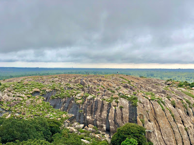
The weather was nice for any type of climb. This was an easy climb that can be done in 5 minutes as it had well-built steps & railings all along. The surroundings were not clearly visible as it was cloudy even at 9 AM. We relaxed a lot of time at the top amidst the temple, that was still closed. One can view the forest area surrounding the rocks from the top.
The weather was nice for any type of climb. This was an easy climb that can be done in 5 minutes as it had well-built steps & railings all along. The surroundings were not clearly visible as it was cloudy even at 9 AM. We relaxed a lot of time at the top amidst the temple, that was still closed. One can view the forest area surrounding the rocks from the top.


We also saw some people atop the adjacent rock. When we were wondering how to get there, we could see a small path between the two rocks. After a while we planned to climb the other rock. We started the descent and from the midway, another sortie was flown that captured some beautiful shots.
In between the two rocks, there was the Rudra Muneshwara Swamy Temple & a water body. We could see some devotees taking a dip there before going to the temple. We then walked further behind the temple to find the path to the other rock. We got the path that was not clearly visible & climbed the rock. It was also an easy climb where we saw a family returning back.


The top of the rock had an almost flat surface that was ideal for me to fly my drone. The rock also had our National flag placed at the other end, may be part of the Independence day (Har Ghar Tiranga) celebrations.


One could get a beautiful view of the temple atop the adjacent rock on one side & beautiful scenes on rest of the directions. A lot of time was spent to fly the drone as my friend relaxed near the flag, under the Sun.


The clouds cleared up as we were about to leave. Finally, we took some cool pictures of the surroundings with the Sun shining bright.


We climbed down in a couple of minutes, walked to the temple at the base & started our return journey. On the way we stopped at a so-called waterfalls to have some fun time in the water.


Later we took the route through Attibele to have our lunch and proceeded to Bangalore via Sarjapur & Varthur.


Watch the Video here: Drone Video of Devarabetta
Watch all my travel videos here: My YouTube Channel and do subscribe for more videos.
For more of my travel stories, do visit My Wanderlust Experiences
Watch all my travel videos here: My YouTube Channel and do subscribe for more videos.
Location: Devarabetta Temple
Distance: 52 Kms (Bangalore-Anekal-Devarabetta)