With the 78th Independence day around, ”Har Ghar Tiranga” slogans were seen all over. A National Flag was distributed to all employees in our office for hoisting at home. But it deserves to fly higher. For that, we decided “Aaj Kuch Toofani Karenge”.
It has been a while we hiked a fort or a hill and my drone too was taking rest for long. Among a lot of options around Bangalore, we finally locked the target as Rayakottai Fort.

Rayakottai Fort is around 70+ Kms from Bangalore. It is located in the Krishnagiri district, Tamil Nadu and a lesser-known gem that is waiting to be explored by history buffs and travel enthusiasts. Located on a hillock, Rayakottai Fort offers panoramic views of the surrounding countryside. The fort is spread over an area of 100 acres and is surrounded by granite walls, which are a marvel of ancient engineering.
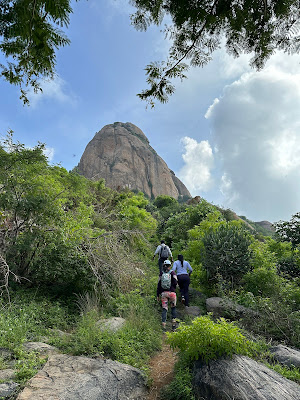
Me and my 3 friends started late at 6:15 am from my home (Bangalore) and halted at Hosur for breakfast. From Hosur, we took the newly constructed NH-844 (which connects Hosur & Dharmapuri, bypassing Krishnagiri). The road was good but still some construction work was in progress. We entered Rayakottai town, drove through the busy market and reached the base 8:15 am. There was a small parking place that was guided by the locals there. It seemed that a make shift parking was made recently at the foothill. We parked our car & started to climb by 8:30 am.
The sun was shining bright at 8:30 am itself. We thought we would have a tough day climbing up. Initially there was neatly laid steps, then transformed into steps made of stones. We saw a family of 3 returning, from where we got a view of the town.

On climbing for a few minutes, we reached a T junction. The left path leads to a cave temple & the right one to the top. We took the one that goes to the top & decided to visit the cave temple while coming down. After a few metres we had another Y junction, the left one leading to the top & the other route going down to the base, behind the hill.
Obviously we took the left one and walked further to enter into an arch, may be the start of the fort. Huge rocks welcomed us to the fort that had some cave like structures on the left side. On the right we could see the other side of the town.


A group of 10-15 men joined us who came from the cave temple, enquiring about us. They had come from Gujarat & were here for 4 months for some work. We waited for them to pass & continued our walk through the perimeter of the hill/fort. There was a small pond that had steps to go down. It might be the water source at that time. We halted there at a stone wall from where we could see a range of hills on the eastern side.

We walked further through the lush green path to another junction where the left one leads you to the topmost point of the hill and the other takes you to the flat area of the fort. We waited for the other group to choose theirs and they took the one to the top. We took the other one so that we could enjoy our private space there. We climbed some huge stones to see almost a flat area that had a few abandoned buildings.


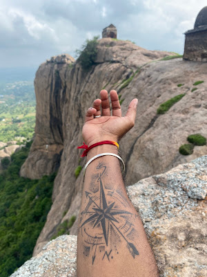
The highlight of the place was this huge rock that was half hanging out of the hill. We took turns to climb on top of it to click some great pics, not to mention the ones with the flag. We even sat on the edge of that rock that looked dangerous in the pics. It wasn’t that dangerous but one needs to be careful. That was the “Toofani” moment of the trip.


From there we could even see the base/entrance steps of the hill. A couple of monkeys were walking on the edge of the rocks that looked dangerous.
It’s now time for some aerial photography and my drone took-off to get some awesome shots of the hill. The link of the drone shots/video is given at the end. We walked through the other end of the fort taking some pics & headed to the top. Only we 4 were there at that moment.

The path was not so tough with few easy rocks to hop on. On the way, the other group crossed us in the opposite direction. A few minutes of walk into the bushes & on the rock that had steps etched on it, we reached the top of Rayakottai Fort.
The top had a small area similar to a stage with few steps to reach there. A small stone wall around that stage that was covered with grass and a big oil lamp in the centre. It was a unique view at the top. The 360o view from the top covering the Rayakottai town & its surroundings were magnificent. We could even see the Krishnagiri reservoir/dam far on the eastern side. The weather was pleasant at that time that we spent almost an hour there. Once again, it was only the 4 of us in the peak, as if it was a private hill with views. We finally hoisted the flag there at a lamp post there.


Another chance to fly my drone there. The (aerial)views from that location was even more picturesque. A monkey followed us up to this top point and was expecting us to share some food items. I took the drone from my bag and as it took off, the monkey ran as far as it can. The weather still was pleasant with a cool breeze and the sun playing hide & seek with the clouds.
The link of the drone shots/video is given at the end.
By 11:00 am we decided to climb down and 2 of my friends took the lead and were out of sight. In no time we (the other 2) crossed the Y junction & reached the T junction to visit the cave temple. As we could not see them, we tried calling them. As we guessed, they had taken the wrong turn at the Y junction.


Later we all met at the T junction & visited the cave temple which was deserted. It was an open temple under the cave that had the idols. It was neatly painted & had many compartments that seemed used for meditation. We sat there for a while before tracing back the same path to the base of the hill.


At 12:00, the sun was burning hot at the base that we could not enter our car. Later we drove back through the Rayakottai market area that had some congestion. The market was full of items for the next day’s Varamahalakshmi Pooja. We took the same NH844 back to Hosur, where we had lunch & then headed back to Bangalore to be at home by 3:00 pm.
Watch the Drone video here:
https://youtu.be/lXMihAijDcU?si=hEZkbL3v6vhEh9S8
Distance: Bangalore to Rayakottai Hill Base: 75 Kms (One way)
Location/Peak:
https://maps.app.goo.gl/A7tAX3S9zt2EzcFj8
Trek Starting Point:
https://maps.app.goo.gl/DKt6NAtHA7CJCjcV7
Trek Distance & Time: 5 Kms (Two way)
Difficulty Level: Easy. Kids too can climb and they will definitely enjoy the hike as well as the view at the top.
Tips: Normal shoes will be sufficient. Do carry water. Try not to go alone and be cautious at the edges.